Integrated Digital Survey Methodologies for Late Medieval Fortifications in Tuscany: The Fortress of Malmantile
Giovanni PANCANI
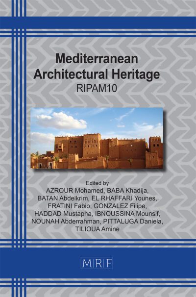
download PDFAbstract. The “castle of Malmantile”, on the hills of Lastra a Signa, was built with the intention of strengthening the Florentine defenses against the rival city of Pisa. It represents one of the most interesting examples of late medieval fortification that has best preserved the entirety of the walls. It was originally built as a military outpost along the ancient road that connected Florence to Pisa. Following the downgrading of the military defense role, it became an inhabited center, a reference point for the surrounding fertile countryside. The data acquisition was carried out in three different survey campaigns, the first two carried out between 2009 and 2010 and the last, completed and updated, carried out in July 2018. The restitution work was carried out to give a complete representation of the place, its constructive characteristics and its state of conservation / decay. Exhaustive thematic maps have been extracted from the obtained documents, which have provided an adequate account of the conditions of the places.
Keywords
Laser Scanner Survey, Malmantile, Walls, Arno Valley, Leonardo Drawing 8P
Published online 3/15/2024, 12 pages
Copyright © 2024 by the author(s)
Published under license by Materials Research Forum LLC., Millersville PA, USA
Citation: Giovanni PANCANI, Integrated Digital Survey Methodologies for Late Medieval Fortifications in Tuscany: The Fortress of Malmantile, Materials Research Proceedings, Vol. 40, pp 363-374, 2024
DOI: https://doi.org/10.21741/9781644903117-38
The article was published as article 38 of the book Mediterranean Architectural Heritage
![]() Content from this work may be used under the terms of the Creative Commons Attribution 3.0 license. Any further distribution of this work must maintain attribution to the author(s) and the title of the work, journal citation and DOI.
Content from this work may be used under the terms of the Creative Commons Attribution 3.0 license. Any further distribution of this work must maintain attribution to the author(s) and the title of the work, journal citation and DOI.
References
[1] G Corsani. (1993), Lastra a Signa. Atlante storico delle città italiane, Toscana, 1, Firenze, Buoninsegni Editore.
[2] A. Baldinotti, R. Barsanti (2003), Capitolo III. Il Ponte, in (a cura di Ciuffoletti Z.), Storia della comunità di Signa, Volume II, L’identità Culturale, Firenze Edifir, pp31-34.
[3]S. Ammirato (1853), Historie Fiorentine. Torino.
[4] G. Romagnoli (2000), Il patrimonio artistico di Lastra a Signa – Architettura Civile, in (a cura di Moretti I.), Il Medioevo nelle colline a sud di Firenze, Firenze, Polistampa, pp. 168-178.
[5] S. Bertocci, G Pancani., A. Cottini (2020), La cinta muraria di Lastra a Signa: metodologie di rilievo digitale integrato, In, Navarro Palazón J: García-Pulido L.J., Defensive Architecture of the Mediterranean, Granada:Universidad de Granada, Universitat Politècnica de València, Patronato de la Alhambra y Generalife, pp. 255-262. https://doi.org/10.4995/FORTMED2020.2020.11498
[6] G Verdiani. (2012), Le metodologie e le strumentazioni per il rilievo laser scanner, in Bini M., Bertocci S. (a cura di), in Manuale di rilievo architettonico e urbano, Capitolo 5.1, Novara, De Agostini Scuola S.p.A., 2012, pp. 169-174.
[7] G. Pancani (2017), La città dei Guidi: Poppi. Il costruito del centro storico, rilievi e indagini diagnostiche, Firenze: Edifir, Firenze, p. 147.
[8]M Docci., , D. Maestri (1994). Manuale di rilevamento architettonico e urbano, Roma-Bari: Laterza Editore.
[9] R De Marco.;, S Parrinello. (2021). Digital surveying and 3D modelling structural shape pipelines for instability monitoring, in, historical buildings: a strategy of versatile mesh models for ruined and endangered heritage, ACTA IMEKO, vol. 10, pp. 84-97, ISSN:2221-870X. https://doi.org/10.21014/acta_imeko.v10i1.895
[10] G. Pancani (2011), Lo svolgimento in vera grandezza delle volte affrescate delle sale dei quartieri al piano terreno di Palazzo Pitti a Firenze, in, Il Disegno delle trasformazioni, atti delle Giornate di Studio , Napoli 1-2 dicembre 2011, Clean Edizioni, Napoli 2011.
[11] G Pancani., S Galassi., L Rovero., L Dipasquale., E., Fazzi ?G Tempesta. (2020), Seismic vulnerability assessment of the triumphal arch of Caracalla in Volubilis (Morocco): past events and provisions for the future, “International Archives of the Photogrammetry, Remote Sensing and Spatial Information Sciences, XLIV-M-1-2020, 435–442. https://doi.org/10.5194/isprs-archives-XLIV-M-1-2020-435-2020
[12 ] M Ceconello. (2003), Strumenti e tecniche di visualizzazione, in (a cura di Gaiani M.), Metodi di prototipazione digitale e visualizzazione per il disegno industriale, l’architettura degli interni e i beni culturali, Milano, Edizioni Polidesign, pp. 511-580.
[13] G. Pancani; M. Bigongiari (2020), Digital survey for the structural analysis of the Verruca fortress, in PROCEDIA STRUCTURAL INTEGRITY, vol. 29, pp. 149-156. https://doi.org/10.1016/j.prostr.2020.11.151
[14] F. Fratini (2023), The Rocca Vecchia fortress in the Gorgona island (Tuscany, Italy): building materials and conservation issues, in Bevilacqua M. G. , Ulivieri (a cura di), Defensive Architecture of the Mediterranean, Vol. XIII / (Eds.), Pisa University Press (CIDIC) / edUPV. https://doi.org/10.12871/9788833397948121
[15] R Barsanti. (2019), Il Paesaggio di Leonardo del 1473 – Studi e interpretazioni, in Barsanti R. (a cura di), Leonardo a Vinci, Alle origini del genio, Firenze, Giunti Editore, p.135-149.